THE SOLUTION IS OUR HANDS
INS - INERTIAL NAVIGATION SYSTEMS
Thanks to its expertise in the field of high-performance fiber optic gyroscopes, iXSea is able to supply high-precision navigation and positioning systems for surface vessels and units.
Equipped with sensors offering ultra high sensitivity to rotation and acceleration, combined gyrocompass and accelerometer assemblies can provide complete information on attitude, speed and acceleration in real time, continuously and at unequalled levels of precision.
Based on the same technology and offering the same benefits, Inertial Navigation Systems (INS) provide information on navigation along with attitude data.
These navigation and positioning systems currently equip more than 1,500 ships engaged in every possible application: DP vessels for offshore operations and dredging, along with oceanographic and hydrographic survey ships fitted with multibeam antennas or towfish.
We can offer following solutions:
HYDRINS
Inertial navigation system for hydrographic & multibeam surveys
FEATURES
• Proven high-performance iXBlue INS technology inside
• Compact, uses any kind of GPS (only one GPS required)
• DELPH INS (windows based) post-processing package included
• GPS drop-out / multipath management
• Smart HeaveTM
• Ethernet, Web-based Man-Machine Interface (MMI)
• Option : GPS RTK
BENEFITS
• Reliable and accurate motion, speed, position and heave data
• Fast and reliable installation on all vessels
• A complete solution packed with easy-to-use yet powerful post-processing tools
• Motion and heading not affected by GPS outages, position remains valid for minutes
• Network ready, intuitive user interface
APPLICATIONS
• Multibeam survey • Hydrographic survey • Harbours and inland waterways Hydrins Inertial navigation system for hydrographic & multibeam surveys
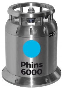
PHINS
High-performance inertial navigation system
FEATURES
• All-in-one high-accuracy 3D positioning with heading, roll and pitch
• Fiber Optic Gyroscope (FOG), unique strap-down technology
• Multiple interfaces (DVL, EM log, GPS and depth sensor)
• Compact, lean and reliable
• Ethernet, Web-based Man-Machine Interface (MMI)
BENEFITS
• Complete navigation unit
• No spinning element hence maintenance free
• Versatile
• Appropriate for all underwater vehicles
APPLICATIONS
• Surface navigation for frigates, MCMV and fast patrol boats• AUV • ROV • HOV • SDV